A journey through a contact metamorphic aureole:
Metamorphism of the Kluane metamorphic assemblage, SW Yukon
If you are interested to to find out what happened to metasedimentary rocks that were previously
metamorphosed under regional greenschist grade metamorphism and then endured the intrusion of a thick granodioritic sill-like
pluton, then you are at the right place!
Introduction: The North American Cordillera and the Kluane metamorphic assemblage
The Kluane metamorphic assemblage (KMA) is located in the northwestern part of the North American Cordillera. In Canada the
Cordillera is subdivided in five belts, from east to west the the Foreland, the Omineca, the Intermontane, the Coast and
the Insular Belts. The belts coincide roughly with different geological regions, that are subdivided into several terranes
(definition of terranes). The belts are the result of accretion of various island arcs onto the North
American continent starting from the Middle Jurassic with the collision of the terranes forming the Intermontane belt.
The miogeocline, a passive continental margin from the Middle Proterozoic on, was detached, folded and thrusted eastward
over the craton. Thus the Foreland Belt, including the Rocky Mountains, was created. Intense metamorphism and plutonism
took place along the suture, the Omineca Belt. A second plutonic-metamorphic belt, the Coast Belt, resulted from the
collision of the Insular Superterrane approximately from the mid-Cretaceous on. To further complicate matters, lateral
displacement of terranes occurred after accretion. However, the exact timing and the amount is still a matter of hot debate.
Up to 3000 km of northward displacement is postulated from paleomagnetic data.
 |
 |
|
Terrane and belt map of the Canadian Cordillera, covering British Columbia Yukon Territory, western
Alberta and southeastern Alaska (modified after Wheeler et al. 1991, DNAG G-2).
|
Geological map of the southwestern Yukon east of the Denali fault zone. Outlined are the Kluane metamorphic assemblage,
various pericratonic assemblages associated with the Yukon-Tanana-Terrane (Aishihik Metamorphic Suite, Nisling assemblage,
Nasina assemblage, White River assemblage), the Late Jurassic-Early Cretaceous Dezadeash Formation, and various Jurassic to
Cretaceous plutonic suites east of the Eocene Ruby Range batholith. Modified after Mezger (1997).
|
The KMA forms a 12km thick sequence of homogeneous, N- to NE-dipping metapelitic rocks,
interlayered with slices of olivine serpentinites. They are exposed in a 150km long, NW-SE striking belt. In the
geological frame work it is situated at the northwestern margin of the Coast Belt, in contact with the Ruby Range
granodiorite, part of a late Mesozoic magmatic belt. To the southwest it is truncated by the Denali fault, separating
the KMA from accreted volcanic island arcs.
The sedimentary protolith of the KMA was deposited in a backarc basin. The geochemical and isotopic data which led to this
conclusion are discussed in detail on the following page. The backarc basin collapsed in the
late Mesozoic during eastward
subduction underneath the North American continental margin, and its sediments were deformed and metamorphosed
under lower amphibolite facies conditions at depth greater than 20 kilometers. At the same time the mylonized schist were
accreted onto the overriding North American plate, represented by the Aishihik metamorphic suite. Encroachment of the
Insular Superterrane led to the development of a magmatic arc, the Coast Plutonic Complex, which was active in the Late
Cretaceous to early Eocene. Its northernmost portion, the Ruby Range Batholith, intruded along the suture between KMA and
North America, and thermally overprinted the schist of the KMA at about 57 Ma, resulting in a wide contact metamorphic
aureole (J. Metamorph. Geol. abstract). The KMA is correlated by some authors to the Mclaren terrane
southwest of the Denali fault in east central Alaska, thus inplying a major dextral offset of (> 400 km) along the Denali
fault (Nokleberg et al., 1985, GSA Bulletin 96). I am not convinced, though.
In the geographical framework, the KMA underlies the Ruby and Dezadeash Ranges west of the Alaska Highway and the
Haines Road , which also provide the best access. Haines Junction is the central village. The KMA has its name from Kluane
Lake , its natural western boundary. Southwest of Kluane Lake , across the Shakwak trench, the magnificent Kluane Ranges
rise up to 2000 m above the valley floor.

|

|
|
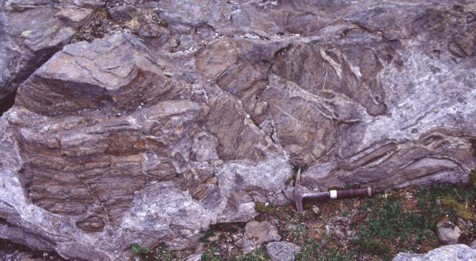
The Ruby Range along the northern Kluane Lake provide a cross section through the contact metamorphic aureole. The
structurally deepest and metamorphic lowest grade rocks are in the south (on the right). The contact with the Ruby Range
batholith is just to the left (north) of the picture. Kluane Lake is the biggest lake in the Yukon Territory and means
'big whitefish lake' in the Southern Tutchone language.
|
View from Jacquot island towards the southern Kluane Lake. The hills on the left are underlain by greenschist grade
muscovite-chlorite schist. To the right (southwest) the impressive Kluane Ranges rise 1500m above the lake level. They are
the northeastern front of the St. Elias Mountains, which are actively rising along a reverse fault, a reactivation of the
Denali fault. The are underlain by low grade Paleozoic-Cenozoic vulcanic arc and oceanic sediments that comprise the
gigantic Insular Superterrane. We are on the former continental margin of North America.
|
Illustrated guide through the KMA contact aureole
This page is a guide through a contact metamorphic aureole: metamorphism imposed on sedimentary rocks by the intrusion of a
pluton , in this case the latest Cretaceous-early Tertiary Ruby Range batholith. The map below is a geological map with
the emphasis on metamorphic mineral assemblages. The mineral isograds are lines that mark the first prograde occurrence of
a metamorphic mineral. Red numbers show the location of the images below.

Below is a generalized cross section through the western part of the Kluane metamorphic assemblage. Thermobarometry
results are shown on a different page.

Start
We begin in the lowest grade metamorphic rocks, those that have not been overprinted by contact metamorphism. They can be
found along the northeastern shore of Kluane Lake : They contain Na-rich plagioclase feldspar, albite [NaAlSi3O8],
muscovite [KAl2AlSi3O10(OH)2], chlorite
[(Fe, Mg, Al)6(Si,Al)4O10(OH)8], quartz [SiO2], calcite [CaCO3],
graphite [C], and locally epidote [Ca2(Al,Fe)3Si3O12] and clinozoisite
[Ca2Al3Si3O12]. The following four pictures show their typical appearance.
Biotite [K(Mg,Fe)3(Al,Fe)Si3O10(OH)2] appears 13km away from the contact
with the batholith. With increasing biotite abundance chlorite is decreasing in percentage:
(1) Chlorite + muscovite = biotite + H20 [The equilibria reactions are shown on a
petrogenetic grid. Click here to view it]
The first garnets [(Fe,Ca,Mg,Mn)3Al2(SiO4)3] are compositionally
zoned with Ca-rich cores (grossular component: 22-34%) and graphite inclusions that can be
spiral-shaped, implying synkinematic growth (Figure).
(2) Chlorite + muscovite + quartz = garnet + biotite + H20
Relict epidote is found as inclusions, suggesting garnet was also produced by breakdown of epidote
(3) Chlorite + muscovite + epidote + quartz = garnet + biotite + plagioclase + H20
The pressure and temperature during the beginning of garnet growth can only be estimated with the program Gibbs 4.7 by Frank
Spear: 7.5 kbar (ca. 25 km depth) and 508°C.
9 km from the intrusive contact staurolite [Fe2Al9O6 (SiO4)4(OH)2]
appears and marks the beginning of the amphibolite facies. Staurolite grows along garnet rims. Not having any spiral-shaped
inclusion trails, it overgrows previously rotated garnets. The stress field has changed: from non-coaxial deformation
(simple shear) to coaxial deformation (flattening or pure shear).
Welcome, now we have entered the contact aureole!

|

|
|
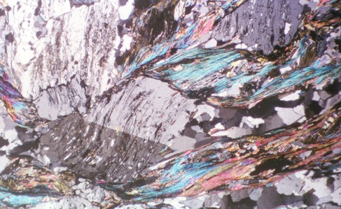
Garnet with spiral-shaped inclusion trails indicating synkinematic growth, and a dextral sense of shear. Yellow
pleochroic staurolite grows at grain boundary of garnet with indication of consumption of garnet, according to reaction(4).
Brown pleochroic mineral is biotite. Plane polarized light (PPL). Location 4 on map. Length of slide ~ 2.5mm.
|
Euhedral staurolite (yellow pleochroic) overgrows shear zone between large light coloured plagioclase porphyroblasts.
Graphite inclusions outline shear zone. Staurolite crystals grew postkinematic. PPL. Length of slide ~10 mm.
|
Along with staurolite, biotite also increases in abundance, while muscovite and chlorite diminish.
Thus we can deduce the following reaction:
(4) Muscovite + chlorite + garnet + quartz = staurolite + biotite + H20
The next minerals to appear are andalusite and needle-shaped sillimanite
(fibrolite), the low-temperature and high-temperature phases of Al2SiO5. Andalusite forms poikiloblastic
porphyroblasts with inclusions of biotite and graphite. Fibrolite occurs along the rims of andalusite grains. With a sharp
increase of andalusite and fibrolite staurolite disappears less than one kilometer “later” and can only be found as
relict inclusions in andalusite. By now chlorite has also dissappeared:
(5) Muscovite + chlorite + quartz + staurolite = andalusite / sillimanite + biotite + H20

|
Staurolite (St) as relict within poikiloblastic andalusite (And). Indication for reaction (5).
Difficult to see, at contact with andalusite at the lower left is fibrolitic sillimanite. Biotite is distinguished by green
and brown interference colors. Location 5 on map. XPL.
Length of slide ~3.5 mm.
|
In some parts no andalusite is observed, only sillimanite. There, the temperature (or pressure) was a bit higher. A
significant change in the appearance of the rocks occurs with the next mineral, cordierite
[(Mg,Fe)2 Al4Si5O18]: The schist becomes coarse and looses its distinct
schistosity. The rock is now a gneiss. This is due to the replacement of biotite, which defines the
schistosity, by cordierite. At the same time, andalusite disappears, and sillimanite and garnet decrease. Cordierite, with
its low relief and lack of colour, can be distinguished by yellow alteration rims, called pinitization. Several
cordierite-forming reactions can be inferred:
(6) Garnet + andalusite / sillimanite + quartz = cordierite
(7) Biotite + andalusite / sillimanite + quartz = cordierite + K-feldspar + melt

|

|
| Plane polarized microphotograph of a typical biotite-cordierite gneiss. Cordierite generally lack graphitic inclusions of the
plagioclase porphyroblasts and does not produce euhedral crystals. Nevertheless, at first glance it can not be easily
distinguished from plagioclase, since cordierite is also colourless and of low relief. Notice that the amount of biotite has
decreased, and the nice schistosity is gone.
|
Field shot of a cordierite gneiss of the Dezadeash Range (Location 6 on map). Notice the wider spaced gneissic foliation
and the absence of distinguishable porphyroblasts compared to the muscovite-chlorite schist of the Kluane Lake shore shown
above.
|

|
| Extremely corroded garnet, partly overgrown
by cordierite, which can be distinguished on this microphotograph only
by its yellow alteration rim (pinitization), indicating the activity
of reaction (6). Location 7 on map. PPL. Length of slide ~3 mm.
|

potassium-feldspar [KAlSi3O8] is difficult to determine by optical microscopy,
since it lacks twinning like plagioclase in the high grade gneisses of the KMA, and its other optical properties do not
allow unambiguous distinction. For that we need the electron microprobe. They can be visualized by images that show the
density of mineral phases by their relative brightness, which correlates to the amount of electrons reflected. This method
is called backscatter imagery. The backscatter image on the right shows that dark grey cordierite (Crd) and lighter grey
potassium-feldspar (Kfs) is consuming biotite (Bt), just as it is expected according to reaction (7). The scale bar is 100
micron.
In the eastern part of the Kluane metamorphic assemblage spacing of mineral isograds increases (see map above).
In the Dezadeash Range the KMA is underlain by granodiorites. Some of them crop out and form little plugs of a few hundred
metres to one kilometre in diameter. IN the contact areas schlieren fabrics are evidence for beginning of migmatization,
or partial melting of the gneiss. Now, we are very close to the contact of the Ruby Range granodiorite.

|
|
|
It is getting hot! Near the contact with the granodiorite plug in the Dezadeash Range (southern part of the KMA -
see location 6 on map) fragments of KMA cordierite gneiss are surrounded by the granodioritic melt. Leucosomes within the
gneiss (red arrow) are indicators that the gneiss itself is starting to melt: the beginning of migmatization.
|
A few hundred meters above the cordierite-in isograd muscovite disappears, and new sillimanite nucleates
(along with more potassium-feldspar):
(8) Muscovite + quartz = K-feldspar + sillimanite + melt
A green, worm-shaped mineral can be observed in cordierite: hercynite, a chromium-rich spinel. The occurrence of anhedral
garnet inclusions in some cordierite crystals and sillimanite surrounding hercynite suggest that spinel was formed by the
reaction:
(9) Sillimanite + garnet = cordierite + spinel
 and garnet (center)")
|
 and fibrolite (sillimanite)")
|
|
Cordierite with inclusions of sillimanite, hercynite (dark green) and garnet (center). Embayment of the garnet suggests that
cordierite and spinel were formed by a garnet and sillimanite consuming reaction (9). PPL. Length of slide ~3mm.
(Location 8 on map)
|
Cordierite porphyrpblasts with inclusions of green spinel (hercynite) and fibrolite (sillimanite). Note the
sillimanite-free zone around hercynite. The reddish brown mineral is biotite. PPL. Length of slide ~1cm.
|
Next to the intrusive contact a new generation of garnet, free of inclusions and consuming biotite, can
be observed:
(10) Biotite + sillimanite + plagioclase + quartz = garnet + cordierite + K-feldspar + melt
 Cordierte-biotite schist above the second garnet isograd, close to the contact with the Ruby Range Batholith in the eastern
Dezadeash Range (location 9 on map). Inclusion-free garnet (notice the difference to the
corroded garnets shown above)
consumes biotite, marking the transition from uppermost amphibolite to lower granulite facies. Compositional cross-section
of this garnet can be viewed
here.
PPL; length of slide ~1.2mm.
Cordierte-biotite schist above the second garnet isograd, close to the contact with the Ruby Range Batholith in the eastern
Dezadeash Range (location 9 on map). Inclusion-free garnet (notice the difference to the
corroded garnets shown above)
consumes biotite, marking the transition from uppermost amphibolite to lower granulite facies. Compositional cross-section
of this garnet can be viewed
here.
PPL; length of slide ~1.2mm.
Now we have reached the transition zone between the amphibolite and the granulite facies,
the highest metamorphic grade
that is preserved in the Kluane metamorphic assemblage. Through our little journey we have experienced a decrease of 3-4kbar
or 12km of movement upwards in the crust to a depth of 13km and a heating of 250°C to 750°C near the contact with the Ruby Range
batholith. You may have recognized that temperatures increase at higher levels, contrary to the expected. However, remember
that in the case of the KMA we don't see a typical regional metamorphism, but a contact metamorphic overprinting. Since the
Ruby Range batholith intruded above the KMA, it produced an inverse contact metamorphic aureole.
And so ends the metamorphic story of the Kluane metamorphic assemblage rocks. Now, all the future holds for them is alteration
and weathering. If this sounds too pessimistic, just think that there are more rocks to come up, and maybe they will tell us
more... .
If you are interested in more details, you can look it up in these articles:
Mezger, J. E.; Chacko, T. & Erdmer, P. (2001):
Metamorphism along a late Mesozoic accretionary continental margin: a case study from the northern Coast Belt of the
North American Cordillera.- Journal of Metamorphic Geology 19, 121-138.
(reprint)
Mezger, J. E. (2003):
Geology of the Dezadeash Range and adjacent areas of the northern Coast Mountains (115A), southwestern Yukon: Re-examination
of a terrane boundary.-
In: Yukon Exploration and Geology 2002 (edited by Emond, D. S. & Lewis, L. L.). Exploration and
Geological Services Division, Yukon Region, Indian and Northern Affairs Canada.
(full length article, 4MB)
Additional literature:
Bucher, K. & Frey, M. (1994):
Petrogenesis of Metamorphic Rocks.-
Springer Verlag, Berlin, New York.
Gabrielse, H. & Yorath, C. J. (Eds.) (1991): Decade of North
American Geology volume G-2: The Geology of the Cordilleran Orogen in Canada.
Kerrick , D. M. (ed.) (1991):
Contact Metamorphism.-
Mineralogical Society of America, Reviews in Mineralogy 26.
Spear, F. S. (1993):
Metamorphic Phase Equilibria and Pressure-Temperature-Time Paths.- American Mineralogical Association Monograph, Washington.
For web-based information look up the Lithoprobe website.
Pages of further interest: